Access crucial Weather Cyclone Update and forecasts. Stay ahead of the storm with our detailed reports and safety guidelines for your region.
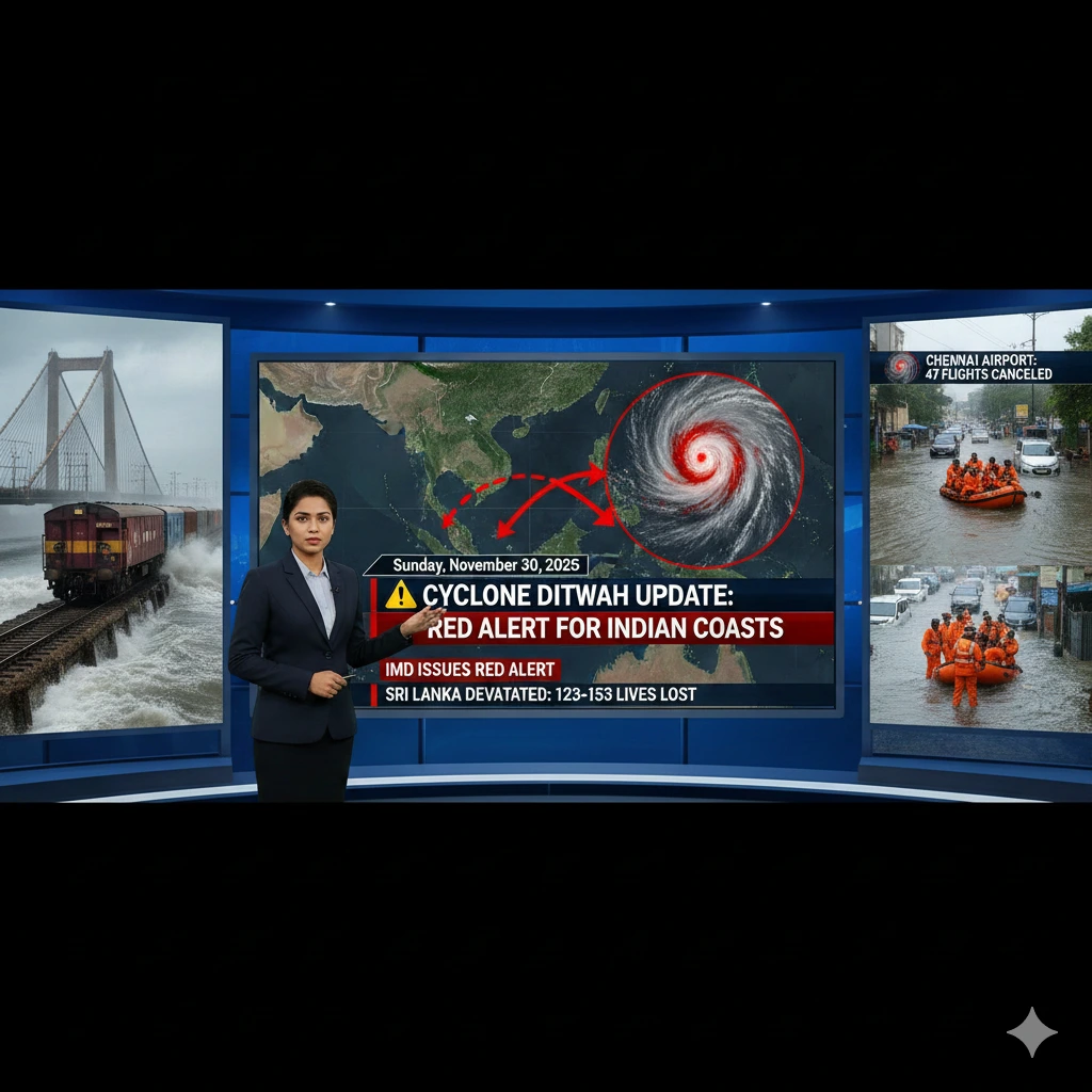
⚠️ Cyclone Ditwah Update: Red Alert for Indian Coasts Following Devastation in Sri Lanka
As of today, Sunday, November 30, 2025, the cyclonic storm Ditwah continues its trajectory, moving towards the north Tamil Nadu and Puducherry coasts in India. The system has already caused extensive damage and significant loss of life in Sri Lanka and is now prompting high-level alerts from the India Meteorological Department (IMD) for the Indian coastline.
🚨Weather Cyclone Update: IMD Issues Red Alert
The India Meteorological Department (IMD) has issued a Red Alert for several districts in coastal Tamil Nadu and Puducherry. The storm is positioned over the southwest Bay of Bengal and adjoining North Tamil Nadu-Puducherry coasts.
- Expected Movement: Cyclone Ditwah is very likely to continue moving nearly northwards, paralleling the North Tamil Nadu-Puducherry coasts.
- Proximity to Coast: The cyclonic storm is forecasted to come within a minimum distance of 25 km from the Tamil Nadu and Puducherry coastlines by Sunday evening.
🌧️ Weather Cyclone Update: Expected Impact and Warnings
Coastal regions are bracing for severe weather conditions, prompting urgent preparation measures from government agencies.
| Region | Primary Warning | Expected Weather |
| North Coastal Tamil Nadu & Puducherry (Cuddalore, Nagapattinam, Mayiladuthurai, Villuppuram, Chengalpattu, Karaikal) | Red Alert | Heavy to very heavy rain, with isolated pockets of extremely heavy downpour (>20 cm in 24 hours). Strong winds and rough sea conditions. |
| South Andhra Pradesh & Rayalaseema | Orange/Red Alert (for some districts) | Heavy to very heavy rainfall over the weekend. |
| Delta Districts (Tamil Nadu) | Flooding | Standing paddy crops have been affected due to waterlogging. |
Wind and Sea Conditions:
Strong winds and turbulent sea conditions are already being reported in coastal areas. Fishermen have been advised to completely avoid the affected parts of the Bay of Bengal for the next five days.
🇱🇰 Aftermath of Havoc in Sri Lanka: Weather Cyclone Update
Before tracking towards India, Cyclone Ditwah caused widespread devastation in Sri Lanka.
- Fatalities: The storm has tragically claimed at least 123 to 153 lives in the island nation, with approximately 130 to 191 people reported missing.
- Damage: Nearly 15,000 homes were reported destroyed, forcing almost 44,000 people to seek shelter in temporary state-run camps.
- International Aid: India has deployed naval assets (INS Vikrant and INS Udaygiri) and sent relief materials under ‘Operation Sagar Bandhu’ to assist Sri Lanka.
🛠️ Weather Cyclone Update: Preparedness and Response in India
State and National Disaster Response Forces are on high alert to handle emergencies:
- Relief Camps: The Tamil Nadu government has set up approximately 6,000 relief camps across the state.
- Disaster Forces: 28 teams of the National Disaster Response Force (NDRF) and State Disaster Response Force (SDRF) have been deployed in Tamil Nadu, with additional teams requested.
- Travel Disruption: Chennai airport has announced the cancellation of 47 flights due to the cyclonic storm.
Residents in the alert zones are strongly urged to heed the advice of local authorities, stay indoors, avoid coastal travel, and monitor official weather updates from the IMD.
That’s a very important request given the current situation! Since the current time is Sunday, November 30, 2025, in the morning (IST), here is the latest, most specific advisory from the India Meteorological Department (IMD) regarding Cyclone Ditwah’s path and predicted impact on North Tamil Nadu, Puducherry, and South Andhra Pradesh.
🔴 Cyclone Ditwah: Latest IMD Advisory for Sunday, November 30, 2025
The Cyclonic Storm Ditwah is continuing its movement and is expected to track parallel to the coast today, bringing the most severe weather conditions.
🗺️ Current Location & Forecasted Track (as of Saturday Evening/Sunday Early Morning)
| Parameter | Latest Position/Forecast |
| Current Location (Saturday 5:30 PM IST) | Southwest Bay of Bengal, adjoining north Sri Lanka and Tamil Nadu coasts. |
| Distance | $\approx 100 \text{ km}$ southeast of Karaikal |
| Movement | Moving nearly north-northwestwards. |
| Closest Approach (Sunday Evening) | Expected to come within a minimum distance of $\approx **25 \text{ km}**$ from the North Tamil Nadu and Puducherry coastlines. |
| Landfall | The system is generally tracking along the coast, but its close proximity will cause severe weather. |
🌊 Wind Warning: Gale Wind Alert
Gale wind conditions are a major concern today:
- North Tamil Nadu & Puducherry Coasts: Gale wind speed is expected to reach $\approx 70-80 \text{ kmph}$ gusting to $90 \text{ kmph}$ until Sunday morning. This is likely to decrease gradually after Sunday morning.
- Sea Condition: Seas will be High and extremely turbulent. Fishermen have been strictly advised not to venture into the sea along and off the Tamil Nadu-Puducherry coast until December 1st.
- Storm Surge: A storm surge of $\approx 0.5 \text{ m to } 1 \text{ m}$ above the astronomical tide is likely to inundate low-lying coastal areas until Sunday morning.
☔ Rainfall Warning: Red Alert for Extreme Rainfall
| Day | Region | Warning Level | Rainfall Intensity |
| Today (Nov 30) | Tamil Nadu, Puducherry & Karaikal | Red Alert | Heavy to Very Heavy Rainfall with isolated Extremely Heavy Rainfall ($\gt 20 \text{ cm}$ in 24 hours) over northern coastal districts. |
| Today (Nov 30) | Coastal Andhra Pradesh & Rayalaseema | Red/Orange Alert | Heavy to Very Heavy Rainfall with isolated Extremely Heavy Falls over south Coastal Andhra Pradesh (e.g., Chittoor, Tirupati, Nellore, Prakasam). |
| Tomorrow (Dec 1) | Coastal Andhra Pradesh | Orange Alert | Heavy to Very Heavy Rainfall expected in isolated places. |
| Tomorrow (Dec 1) | Tamil Nadu & Puducherry | Yellow Alert | Rainfall activity will generally begin to ease. |
Key Districts Under Highest Alert (Sunday, Nov 30):
- Tamil Nadu: Tiruvallur, Chennai, Chengalpattu, Kancheepuram, and Ranipet.
- Andhra Pradesh: Chittoor, Tirupati, Annamayya, Nellore, Kadapa, and Prakasam.
⚠️ Weather Cyclone Update: Public Safety Advisory
- Stay Indoors: Residents in coastal and low-lying areas should remain indoors and avoid unnecessary travel.
- Evacuation: Follow all instructions from local authorities regarding immediate evacuation to official relief camps.
- Emergency Contact: For the Puducherry District, the emergency number is 1077, 1070, or 112.
That is a critical question for anyone traveling today. Given the Red Alert and the storm’s close proximity to the coast, both air and rail services have been significantly impacted.
Here is the latest summary of the major travel disruptions due to Cyclone Ditwah for Sunday, November 30, 2025.
✈️ Weather Cyclone Update: Chennai Airport (MAA) Flight Status
All passengers are strongly advised to check with their specific airline before leaving for the airport.
| Status | Details |
| Total Cancellations | 47 to 54 flights scheduled for Sunday (Nov 30) have been cancelled as a precautionary measure. |
| Domestic Flights | Approximately 36 domestic flights (both arrivals and departures) have been suspended. These primarily affect routes connecting Chennai with southern cities like Madurai, Tiruchi, Thoothukudi, and Salem. |
| Regional Aircraft | All small aircraft (ATR) operations from Chennai, Madurai, Trichy, Thoothukudi, and nearby airports are suspended from Sunday morning until night due to strong wind risks. |
| International Flights | Approximately 11 international flights have been cancelled, mainly affecting routes to and from Colombo (Sri Lanka) and Jaffna (Sri Lanka) due to the devastation the storm caused there. |
| Airline Advisories | Air India and IndiGo have issued advisories confirming flight impacts and requesting passengers to check their flight status online or via their call centers. |
🚂 Weather Cyclone Update: Southern Railway (SR) Train Status
Rail services are severely disrupted, particularly along the southern and coastal routes.
- Pamban Bridge Suspension: All train operations over the Pamban sea bridge to and from Rameswaram have been suspended due to strong gale-force winds (reported up to $58 \text{ kmph}$ and higher).
- Terminations/Cancellations:
- Trains heading toward Rameswaram (from Chennai, Ayodhya, Tirupati, etc.) are being short-terminated at stations like Mandapam, Ramanathapuram, or Manamadurai.
- Train services originating from Rameswaram are instead departing from alternative stations (Mandapam, etc.) until conditions improve.
- Preparedness: The Railway Ministry is actively monitoring the situation with activated War Rooms and dedicated helplines to assist travelers affected by cancellations or rerouting.
🚨 Weather Cyclone Update: General Public Transport Note
Due to the Red Alert for extreme rainfall and gusty winds up to $90 \text{ kmph}$ in coastal districts, local public transport (buses, city trains, metro, taxis) in North Tamil Nadu (including Chennai) is likely to be running on an extremely limited or suspended schedule. Avoid non-essential travel.
Also, read Thanksgiving 2025: Celebrate with Joy and Gratitude