Explore the significance of the Southwest Monsoon, its seasonal patterns, and effects on ecosystems and agriculture. Understand its vital role in weather systems.
The Great Indian Rain Delay: 5 Atmospheric Systems Stalling the 2026 Southwest Monsoon
By Trending News Fox Weather Desk
Published: June 19, 2026
The Southwest Monsoon—the lifeblood of India’s agricultural economy—is currently locked in a high-stakes atmospheric tug-of-war. While the monsoon made a relatively timely landfall over Kerala on June 4, its critical western arm has ground to a sudden halt.


Millions of citizens across Maharashtra, Gujarat, and central India are facing an extended, sweltering heatwave. Mumbai has already missed its typical June 11 arrival date by over a week, and countrywide rainfall numbers have plummeted to a staggering 38% deficit for the first half of June.
According to data released by the India Meteorological Department (IMD), the culprit isn’t a simple localized delay. Instead, meteorologists have identified a rare convergence of five distinct rain-suppressing weather systems working against the monsoon simultaneously.
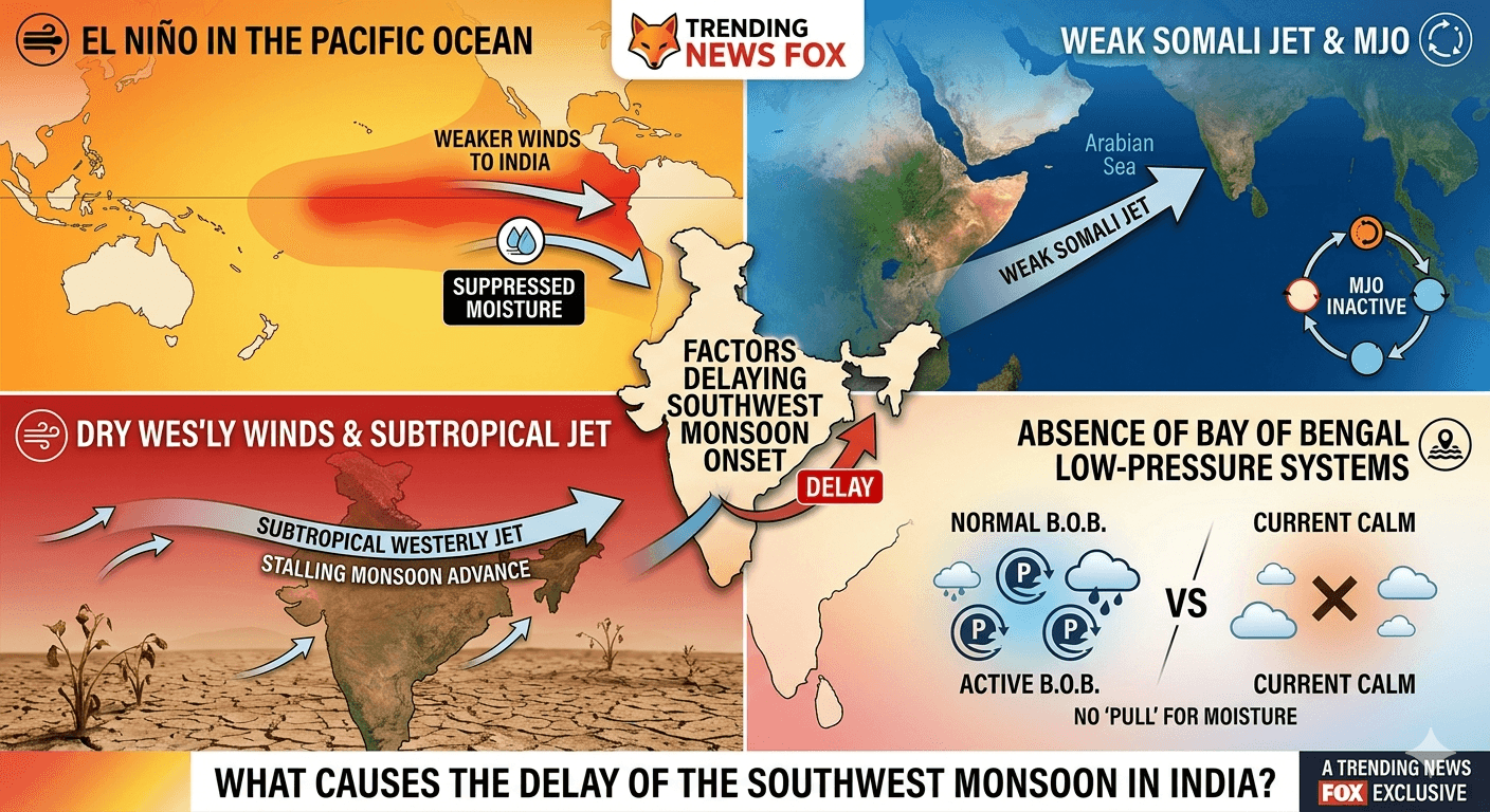
1. The Super El Niño Influence
While local factors heavily govern early June rainfall, the overarching shadow of a developing “Super El Niño” is already disrupting the global climate engine. The periodic warming of the central and eastern Pacific Ocean alters upper-level wind patterns across the globe. This year, it is actively weakening the standard monsoonal pressure gradient, making it difficult for rain clouds to organize.
2. A Weakened Somali Jet & Cross-Equatorial Flow
For a robust monsoon, India relies on the Somali Jet—a low-level, high-velocity wind current that acts as a conveyor belt, pumping massive amounts of moisture across the equator from the western Indian Ocean into the Arabian Sea. Currently, this cross-equatorial flow has severely lost momentum. Without this “oomph,” the winds reaching India’s western coast are sluggish and lacks the necessary moisture punch to push inland.
3. The Invasion of Dry Continental Westerlies
A dramatic tug-of-war is unfolding between tropical air and mid-latitude weather systems. Usually, a vigorous summer monsoon easily pushes mid-latitude westerly winds northward out of the Indian subcontinent. However, because the monsoon is weak, a series of strong Western Disturbances over North India have allowed dry, continental air from the northwest to sweep southward. This dry air intrusion acts like an invisible barrier, evaporating moisture and suppressing cloud formation (convection) over central and western India.
4. An Unfavorable Madden-Julian Oscillation (MJO)
Think of the Madden-Julian Oscillation as a massive, traveling band of rain and clouds that circles the globe along the equator every 30 to 60 days. When it passes over the Indian Ocean in a “favorable phase,” it supercharges rainfall. Unfortunately, the MJO is currently sitting in an inactive, suppressed phase for the Indian region, denying the monsoon its seasonal atmospheric boost.
5. A Ghost Town of Low-Pressure Systems
Historically, the steady advancement of the monsoon requires tactical support from regional low-pressure systems, depressions, or cyclonic circulations. These systems act like atmospheric vacuum cleaners, pulling the moisture-laden arms of the monsoon deep into the mainland. Right now, both the Arabian Sea and the Bay of Bengal are entirely devoid of these helpful low-pressure systems. Even the remnants of Pacific typhoons, which typically cross over into the Bay of Bengal to feed the monsoon, have been completely absent this June.
A Tale of Two Indias: The Current Breakdown
The breakdown of the 2026 monsoon presents a fascinatingly lopsided map. Because the monsoon advances in two distinct arms, different parts of the country are experiencing entirely different realities.
| Region | Status | Deficit / Surplus | Meteorological Driver |
| Northwest India | Ahead of Schedule | 3% Surplus | Repeated Western Disturbances bringing unseasonal rain. |
| East & Northeast | Steady Advance | Near Normal | The Bay of Bengal branch successfully advanced into Bihar and Bengal. |
| Central India | Severely Stalled | 62% Deficit | Complete lack of wind convergence and severe dry air intrusion. |
| West Coast (Mumbai/Gujarat) | Paused | Large Deficit | Weak Arabian Sea surge; stalling since June 8. |
The Expert Take: “The issue right now is not a complete lack of moisture,” explains Dr. Raghu Murtugudde, visiting professor at IIT Kanpur. “The winds are blowing and carrying moisture a couple of kilometers up as expected. However, strong atmospheric subsidence (sinking air) is crushing the convection. Without convergence between the Arabian Sea jet and the return flow from the Bay of Bengal, the core monsoon zone remains dry.”
Southwest Monsoon: When Will the Rains Arrive?
There is light at the end of the dry spell. Latest numerical weather models from the IMD indicate that a meaningful atmospheric shift is on the horizon.
Increased rainfall activity is projected to ignite along the Konkan coast and Mumbai around June 24–25, signaled by a slow strengthening of the Arabian Sea surge. Additionally, weather systems are expected to finally push further into parts of Telangana, Chhattisgarh, and Odisha by June 23. Until then, agricultural experts are advising farmers in central and western states to delay the sowing of kharif crops to avoid seed damage from the dry soil.
Stay tuned to Trending News Fox for real-time weather updates, satellite imagery tracks, and regional monsoon alerts.